![]()
| Home Michael Ammar Solar System Solar System Summary Sun Sun's Statistics Mercury Mercury's Statistics Venus Venus' Statistics Earth Earth's Statistics Mars Mars' Statistics Asteroid Field Asteroid Field's Statistics Jupiter Jupiter's Statistics Saturn Saturn's Statistics Uranus Uranus' Statistics Neptun Neptun's Statistics Pluto Pluto's Statistics Picture Library |
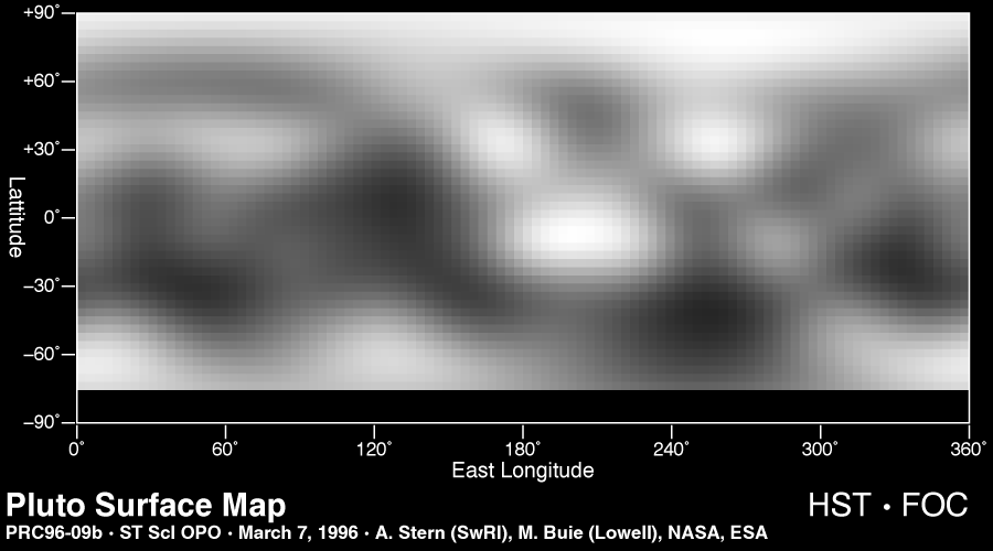 |
| Map of the Surface of Pluto This is the first image-based surface map of the solar system's most remote planet, Pluto. The map, which covers 85% of the planet's surface, confirms that Pluto has a dark equatorial belt and bright polar caps, as inferred from ground-based light curves obtained during the mutual eclipses that occurred between Pluto and its satellite Charon in the late 1980s. The brightness variations in this map may be due to topographic features such as basins and fresh impact craters. However, most of the surface features are likely produced by the complex distribution of frosts that migrate across Pluto's surface with its orbital and seasonal cycles and chemical byproducts deposited out of Pluto's nitrogen-methane atmosphere. Names may later be proposed for some of the larger regions. Image reconstruction techniques smooth out the coarse pixels in the four raw images to reveal major regions where the surface is either bright or dark. The black strip across the bottom corresponds to the region surrounding Pluto's south pole, which was pointed away from Earth when the observations were made, and could not be imaged. (Courtesy NASA/ESA/ESO) |
Send mail to [email protected] with questions or comments
about this web site.
Copyright � 1998 Michael Ammar.
